RESOURCES FOR
|
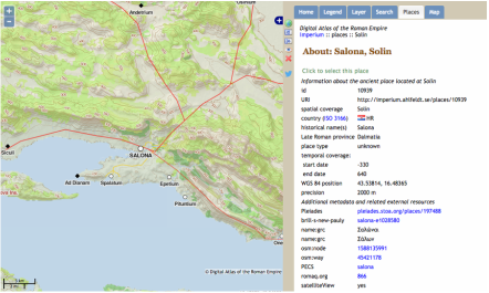
"Salona." From the Digital Atlas of the Roman Empire (http://imperium.ahlfeldt.se/places/10939.html)
Online Resources (in no particular order)LacusCurtius (University of Chicago). In particular, his Gazetteer of the Roman World walks through (mostly Roman) sites with photos and descriptions. He provides useful explanatory photos and references to the sites (and the events that took place there) in ancient literature.
Stanford Digital Forma Urbis Romae Project (Stanford University). This collaboration between computer scientists and archaeologists aims to "solve the map" - or Severan marble plan - of Rome. In the meanwhile, it provides a good resource for exploring the imperial city not just in terms of locating major monuments but in wider urban, commercial, and residential contexts. Ancient World Mapping Center (University of North Carolina at Chapel Hill). This research center was the force behind the Barrington Atlas of the Greek and RomanWorld (2000), which is also an incredibly useful resource! The AMWC continues to produce maps (many of which are available as free downloads) and to refine the geographical dataset for the ancient world (many of which are available for download as free .shp files for GIS) in partnership with the Pleiades Project. Pleiades (ISAW, NYU). Pleiades is a useful resource for finding and visualizing material and sites: you can key in search terms to limit the map to sites that have baths, for example, and then filter out those sites that have been tagged as having baths. You can click on the site names to find location (and its accuracy), and further information links (e.g., for Salona in Croatia) linked to other databases like the Digital Atlas of the Roman Empire. Digital Atlas of the Roman Empire. You can search for places by their modern or ancient place names, which will turn up information such as the type of monuments recorded at the site. Digital Atlas of Roman and Medieval Civilizations (Harvard). Like the Digital Atlas of the Roman Empire, DARMC allows you to search for place names, but it will also, like Pleiades, allow you to search for certain elements (roads, bridges, etc.). ORBIS. The Stanford Geospatial Network Model of the Roman World (Stanford). The interactive ORBIS model reconstructs the duration and financial cost of travel in antiquity, allowing you to calculate travel times according to origin, destination, season, and type of transportation. ConferencesArchaeological Institute of America Annual Meeting
Roman Archaeology Conference Theoretical Roman Archaeology Conference American Schools of Oriental Research Society for American Archaeologists |
- portfolio home
- teaching philosophy
- teaching interests
-
course syllabus
- art and archaeology of ancient italy
- ancient myth: east and west
- archaeology of the late roman empire >
- data analysis and visualization >
- greek and roman epics
- saints and sacred spaces
- constantinople: queen of cities
- travel in the ancient world
- GIS and Remote Sensing in Archaeology and History
- food and drink in the ancient mediterranean >
- the body in greek art and archaeology
- pilgrimage in the ancient world >
- sample materials
- research
- curriculum vitae
- history of archaeological thought and practice
- roman archaeology
